


According to Hindu mythology, this is the place from where the Hindu god Rama built a bridge, across the sea to Lanka to rescue his wife Sita from her abductor Ravana. The Ramanathaswamy Temple dedicated to the Hindu god Shiva is located at the centre of the town and is closely associated with Rama. The temple along with the town is considered a holy pilgrimage site for both Shaivites and Vaishnavites.
Rameswaram is the closest point to reach Sri Lanka and geological evidence suggests that the Adam's Bridge was a former land connection between India and Sri Lanka. The town is in news over alleged attack by Sri Lankan navy for alleged cross border activities by fishermen, Sethusamudram Shipping Canal Project, Kachchatheevu and Sri Lankan Tamil refugees. Rameswaram is administered by a municipality established in 1994. The town covers an area of 53 km2 and had a population of 37,968 as of 2001. Tourism and fishery employ the majority of workforce in Rameswaram.
History
Rameswara means "Lord of Rama" in Sanskrit, an epithet of Shiva, the presiding deity of the Ramanathaswamy Temple. According to Hindu epic Ramayana, Rama, the seventh avatar of the god Vishnu, prayed to Shiva here to absolve any sins that he might have committed during his war against the demon-king Ravana in Sri Lanka. According to the Puranas (Hindu scriptures), upon the advice of sages, Rama along with his wife Sita and his brother Lakshmana, installed and worshipped the lingam (an iconic symbol of Shiva) here to expiate the sin of Brahmahatya incurred while killing of the Brahmin Ravana. To worship Shiva, Rama wanted to have the largest lingam and directed his monkey lieutenant Hanuman to bring it from Himalayas. Since it took longer to bring the lingam, Sita built a small lingam, which is believed to be the one in the sanctum of the temple. This account is not supported by the original Ramayana authored by Valmiki, nor in the Tamil version of the Ramayana authored by Tamil poet, Kambar (1180–1250 CE). Support for this account is found in some of the later versions of the Ramayana, such as the one penned by Tulasidas (15th century). Sethu Karai is a place 22 km before the island of Rameswaram from where Rama is believed to have built a floating stone bridge, the Adam's bridge, that further continued to Dhanushkodi in Rameswaram till Talaimannar in Sri Lanka. According to another version, as quoted in Adhyarma Ramayana, Rama installed the lingam before the construction of the bridge to Lanka.
The history of Rameswaram is centred around the island being a transit point to reach Sri Lanka (Ceylon historically) and the presence of Ramanathaswamy Temple. Tevaram, the 7th–8th century Tamil compositions on Shiva by the three prominent Nayanars (Saivites) namely Appar, Sundarar and Thirugnanasambandar. The Chola king Rajendra Chola I (1012 – 1040 CE) had a control of the town for a short period. The Jaffna kingdom (1215–1624 CE) had close connections with the island and claimed the title Setukavalan meaning custodians of the Rameswaram. Hinduism was their state religion and they made generous contribution to the temple. Setu was used in their coins as well as in inscriptions as marker of the dynasty.
According to Firishta, Malik Kafur, the head general of Alauddin Khilji, the ruler of Delhi Sultanate, reached Rameswaram during his political campaign in spite of stiff resistance from the Pandyan princes in the early 14th century. He erected a mosque by name Alia al-Din Khaldji in honour of victory of Islam. During the early 15th century, the present day Ramanathapuram, Kamuthi and Rameswaram were included in the Pandya dynasty. In 1520 CE, the town came under the rule of Vijayanagara Empire. The Sethupathis, the breakaway from Madurai Nayaks, ruled Ramanathapuram and contributed to the Ramanathaswamy temple.The most notable of them are the contributions of Muthu Kumara Ragunatha and Muthu Ramalinga Sethupathi, who transformed the temple to an architectural ensemble.The region was repeatedly captured several times by Chanda Sahib (1740 – 1754 CE), Arcot Nawab and Muhammed Yusuf Khan (1725 – 1764 CE) in the middle of 18th century. In 1795 CE, Rameswaram came under the direct control of the British East India Company and was annexed to the Madras Presidency. After 1947, the town became a part of Independent India.
Geography
Rameswaram has an average elevation of 10 metres (32 feet). The island is spread across an area of 61.8 square kilometres and is in the shape of a conch. 74% of the area has sandy soil due to the presence of sea and it has many islands surrounding it, the Palk Strait in the north west and Gulf of Mannar in the south East. The Ramanathaswamy Temple occupies major area of Rameswaram. The beach of Rameswaram is featured with no waves at all – the sea waves rise to a maximum height of 3 cm and the view looks like a very big river. Rameswaram has dry tropical climate with low humidity, with average monthly rainfall of 75.73 mm, mostly from North East monsoon from October to January. The highest ever temperature recorded at Pamban station was 37 °C and the lowest was 17 °C.
Adam's Bridge is a chain of limestone shoals, between Rameswaram and Mannar Island, off the northwestern coast of Sri Lanka. Geological evidence suggests that this bridge is a former land connection between India and Sri Lanka. The bridge is 18 miles (30 km) long and separates the Gulf of Mannar (South West) from the Palk Strait (North East). It was reportedly passable on foot up to the 15th century until storms deepened the channel. The temple records record that Rama’s Bridge was completely above sea level until it broke in a cyclone in 1480 CE. The bridge was first mentioned in the ancient Indian Sanskrit epic Ramayana of Valmiki. The name Rama's Bridge or Rama Setu (Sanskrit; setu: bridge) refers to the bridge built by the Vanara (ape men) army of Rama in Hindu mythology, which he used to reach Lanka and rescue his wife Sita from the demon king Ravana. The Ramayana attributes the building of this bridge to Rama in verse 2-22-76, naming it as Setubandhanam. The sea separating India and Sri Lanka is called Sethusamudram meaning "Sea of the Bridge". Maps prepared by a Dutch cartographer in 1747 CE, available at the Tanjore Saraswathi Mahal Library show this area as Ramancoil, a colloquial form of the Tamil Raman Kovil (or Rama's Temple). Many other maps in Schwartzberg's historical atlas[29] and other sources such as travel texts by Marco Polo call this area by various names such as Sethubandha and Sethubandha Rameswaram.
Transport
By Air
Nearest Airport in Madurai - 174 km Indian Airlines connect’s Madurai with Chennai, Thiruchi, Bangalore and Mumbai.
By Train
Connected with all major cities like Bangalore, Chennai, Coimbatore, Madurai, Trichy,Tirunelveli
By Road
Connected with all important towns of Tamil Nadu, City Buses are available including night services. Point to Point services, Tourist taxi, auto / cycle rickshaws and horse carts are also available.The taxi charges for a small car (Indica) is around Rupees 5 per KM. It costs around Rupees 1800 for return trip from Madurai to Rameswaram. Andhra Pradesh State Road Transport corporation ( APSRTC ) operates Rameswaram – Tirupathi daily service.
Tourism Places
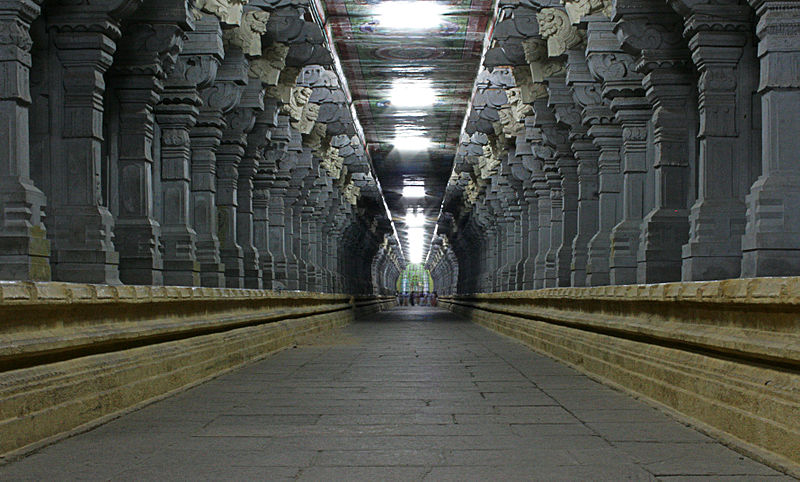
- Sri Ramanathaswamy Temple - this temple situated near the sea on the eastern side of the island is renowned for its magnificent prakaras or corridors with massive sculptured pillars on either side. The longest corridor in the world is here and it is 197 metres long from East to West and is 133 metres wide from South-North. The temple has a Gopuram 38.4 metres tall. Different rulers built the temple as it stands today, at different periods from the 12th century A.D. Pooja is performed for an hour early morning daily to the Spadikalingam that was given by the Shankaracharya to this temple. There is a popular belief that one needs to take bath in 22 theertha kundams with in the temple premises before having darshan. There many guides who will approach us as soon as we enter the temple premises. One needs to negotiate the deal of how much to pay them if we need their services. It is believed that the water from these kundams have some medicinal properties. The history of the temple is linked with "Ramayan" and it is believed the the diety was installed by Lord Rama after the war with Ravana at the instance of the great saints to get rid of the "Brahma Dosham".
- Agnitheertham - Sri Ramanathaswamy temple faces east. The seashore, about 100 metres from the main entrance of the temple, is very calm and therefore ideal for bathing. The water at this place is considered sacred and known as Agni theertham. Pilgrims perform poojas in honour of their ancestors at this seashore.
- Gandamadana Parvatham - is a hillock situated 3 km away and is the highest point in the island. Here one can see the imprint of Lord Rama’s feet on a chakra. The entire island of Rameswaram is visible from this point.
- Sugreevar Temple/Theertham - is situated on the way to Gandamadana Parvatham near the Doordarshan Kendra.
- Satchi Hanuman Temple - is considered to be the place where Hanuman delivered the good news of finding Sita to Rama with satchi or evidence, Choodamani or the jewel that belonged to Sita. Situated 3 km from the main temple, on the way to the Gandamadana Parvatham.
- Badrakaliamman Temple - is a temple for Devi Durga, situated 2 km from the main temple on the way to the Gandamadana Parvatham.
- The Five-faced Hanuman Temple (2 km from the main temple) - the deity of Hanuman drawn withsenthooram. Idols of Lord Ram, Sita and Hanuman brought from Dhanushkodi during the 1964 cyclone were placed here. The floating stone, used to build theSethuBandanamor the bridge between India and Lanka can be found in this temple.
- JadaTheertham (about 3.5 km from Rameswaram on the Dhanushkodi road) - legend has it that Lord Rama, on his way back after killing Ravana, Worshipped SriRamalinga (believed to be installed by him). Before doing so, he washed his hair(Jada) in this theertham to purify himself.
- Nambu Nayagiamman Temple - is greatly venerated by the people of Ramnad District. It is situated 8 km from the main temple in Rameswaram on the way to Dhanushkodi.
- Kothandaramaswamy Temple - is located 12 km away from Rameswaram. A popular belief is that Vibishana, brother of Ravana, surrendered before Rama here.
- Dhanushkodi (18 km) - the southern tip of the island, Dhanushkodi was completely washed away by the 1964 cyclone. This is a strip of land about one km wide and 18 km long on the eastern end of Rameswaram island. On one side are the waters of the Indian Ocean and on the other the waters of the Bay of Bengal. The two seas otherwise known as Ratnakaran and Mahodadhi with their confluence is shaped like a bow while the strip of land resemble an arrow poised for release. Devout Hindus consider the Adi Sethu or the arrowhead, a sacred place to perform religious rites. It is also place worth visiting for its scenic beauty and bird life.
- Villoondi Theertham - is situated 7 km from the main temple on the way to Pamban.
- Annai Indira Gandhi Road Bridge (12 km) - is also known as the Pamban Bridge that connects the Rameswaram island with the main land. It is the longest sea bridge in India and its length is nearly 2.2 km and stands as a fine example for Indian architecture. The bridge was constructed with sufficient elevation. The islands near by and parallel rail bridge below can be viewed from this bridge.


 Posted in:
0 comments:
Post a Comment